Our computer vision-based approach enables farmers to deploy available resources far more precisely and efficiently. By analysing drone or satellite imagery of fields and arable land, it becomes possible to pinpoint exactly where irrigation, the application of pesticides or fertilisers, and the trimming of vegetation are required.
As part of an ongoing pilot project, we are already delivering deadwood identification and optical assessments of plant health.
With our precision agriculture solution, farmers can use resources more efficiently while simultaneously increasing yields.
What we deliver:
- GDPR-compliant storage and processing of image data
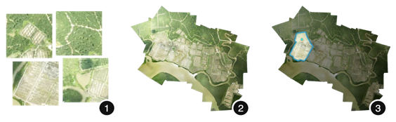
- Fully automated stitching of aerial imagery into an orthomosaic
- Segmentation of areas requiring fertilisation, affected by drought stress or pest infestation
- Vegetation management: irrigation, spraying, pruning
- Exportable action maps for agricultural machinery and field planning