Drone surveys generate large volumes of high-resolution imagery in a short time — imagery that is barely economical to evaluate manually. Our computer vision pipeline processes this raw data fully automatically: from photogrammetric 3D reconstruction through to georeferenced damage maps or progress reports.
How it works:
From overlapping drone images, our models first reconstruct a georeferenced orthomosaic and a digital surface model (DSM). Trained computer vision models then analyse the imagery for specific objectives — whether that is damage detection following a storm event or progress tracking on a large construction site.
Typical applications:
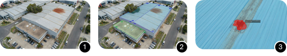
Roof and building inspection
- Automated segmentation of roof surfaces, material types and roof pitches
- Detection and classification of storm damage: missing or displaced tiles, cracks, deformations, water ingress points
- Area-accurate damage maps with GPS coordinates for insurers and tradespeople
- Significant reduction in on-site time for surveyors and loss adjusters
Construction site monitoring
- Periodic comparison of georeferenced imagery for progress documentation
- Volume calculations for earthworks, excavation and material stockpiles
- Actual-vs-planned comparison against construction drawings and BIM models
- Automated reporting for clients and project management
What we deliver:
- GDPR-compliant storage and processing of image data
- Photogrammetric 3D reconstruction (orthomosaic, DSM, point cloud)
- Automated segmentation and measurement of roof and open surfaces
- AI-assisted detection and classification of damage and construction progress
- Exportable results: GeoTIFF, GIS shapefiles, PDF report, LAS/LAZ point cloud
- Integration into existing planning and documentation software